A hunter in a blaze-orange cap with a scoped rifle on her shoulder, standing at the edge of a dark spruce forest.

Is it legal to hunt here, right now?

Huntable reads British Columbia's hunting regulations, private land, parks, road corridors and legal light for the exact spot under your crosshair, and gives you one answer. It works with no signal.

Coming to Google Play first, iPhone after. The legal check is free in every BC hunting region.

Open here
Mule deer is open to you, and every rule the app can check allows it.
Unit 8-12 · Crown land · legal until 6:55 p.m.

Six answers, and the reason for each

Every check ends in one of these. Each has its own colour and its own pattern, so you can tell them apart in glare, with colour blindness, or on the red night screen.

Open here

A season is open to you, it's Crown land you can hunt, and it's legal light.

Ask first

The rules allow it, but it's private land. You need the owner's permission.

Can't confirm

Your GPS circle touches two kinds of land, or the data can't settle it. The app won't guess.

Not here

A park, ecological reserve, wildlife area, town or highway corridor that's closed to hunting.

Not now

The place is fine, the clock isn't. It tells you when legal light starts.

Out of season

Nothing is open to you here today, and it gives the date the next season opens.

A hunter in camouflage climbing a steep grassy mountainside with a rifle, a long valley below.
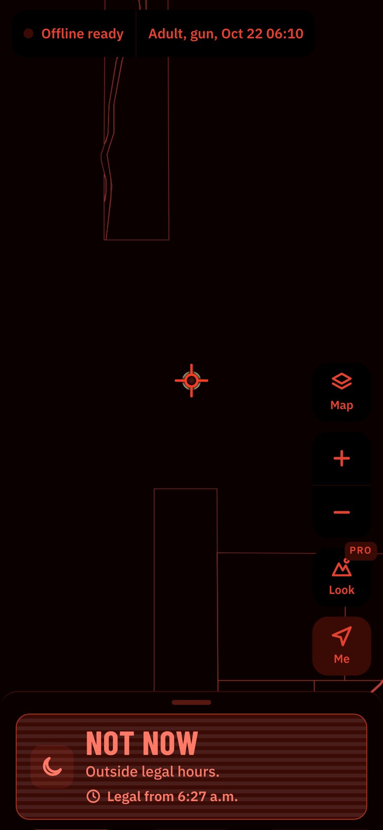
Huntable's night screen, red on black: Not now, outside legal hours, legal from 6:27 a.m.

Built for a cold morning with no signal

Save your region once and every check works offline: seasons, parcels, parks, roads and the clock all live on your phone.

Before legal light, switch to Night. Everything turns dim red on black so your eyes stay adjusted to the dark. On Auto it switches by itself when the sun is down.

Move the map and whatever is under the crosshair is checked when you let go. The buttons are sized for gloves and sit where your thumb is.

What every answer checks

Your age, weapon and the date and time you pick change the answer. Each check shows its source and the synopsis page it comes from.

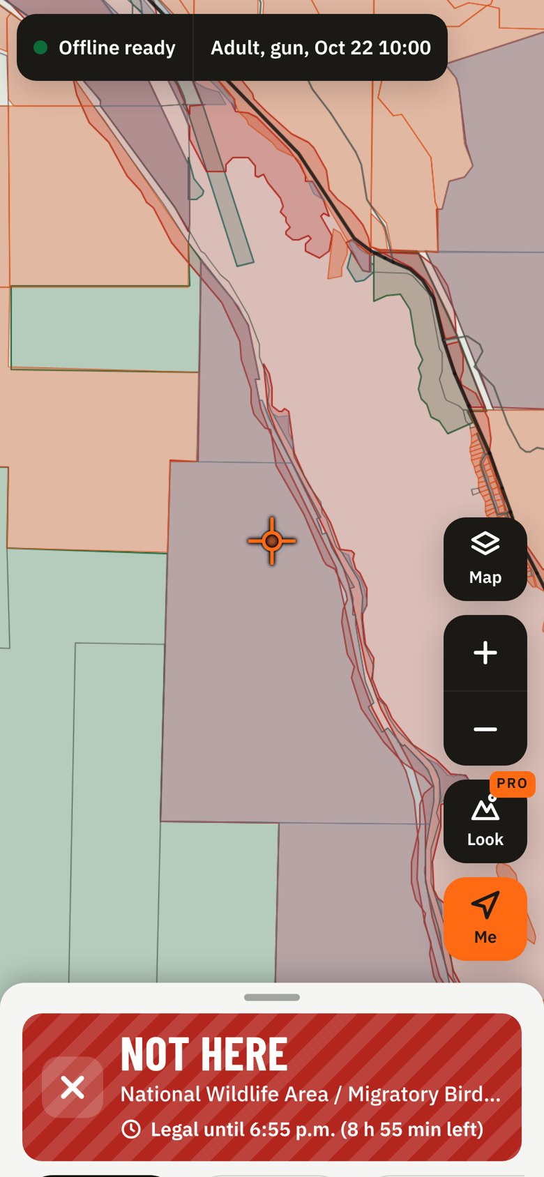
Vaseux Lake on the Huntable map: Not here, a National Wildlife Area and migratory bird sanctuary.

See the boundaries before you walk them

Private parcels, parks, wildlife areas and corridors are drawn on the map, and the answer comes with what to do next: ask the owner, wait for legal light, or head to the nearest spot that comes back Open.

A Before you shoot checklist covers what no map can know: posted signs, buildings within 100 m, livestock and in-season closures.

Two hunters on a ridge at dusk, one pointing across the valley toward a far hillside.

Check the spot your partner is pointing at

Type a lake, creek, peak or town from BC's 39,000 official place names, or paste coordinates straight from a GPS unit, a map link or a text from your hunting partner. Huntable reads decimal degrees, Garmin-style minutes, degrees-minutes-seconds and UTM from forestry maps.

Brenda LakeN49 29.472 W119 35.23811U 312636 5485280Unit 8-12

It shows how it read the numbers before it checks, and copies the answer's coordinates back out in the format you use.

Two mule deer bucks with heavy antlers standing in dry autumn grass.

Pro: know where to look, not just where you can

MooseMule deerElkWhitetail

Pro shades the best Crown land for the date you hunt. It ranks each hectare from burns, cutblocks, wetlands, winter range, terrain and distance from roads, and only shades land that's open to you.

It also lists the best spots within 5 km of you, and why each one ranks.

CA$49.99 a year7 days free, then billed yearly
CA$9.99 a monthBilled monthly, cancel anytime

The legal check stays free. Subscriptions are billed through Google Play and renew until you cancel.

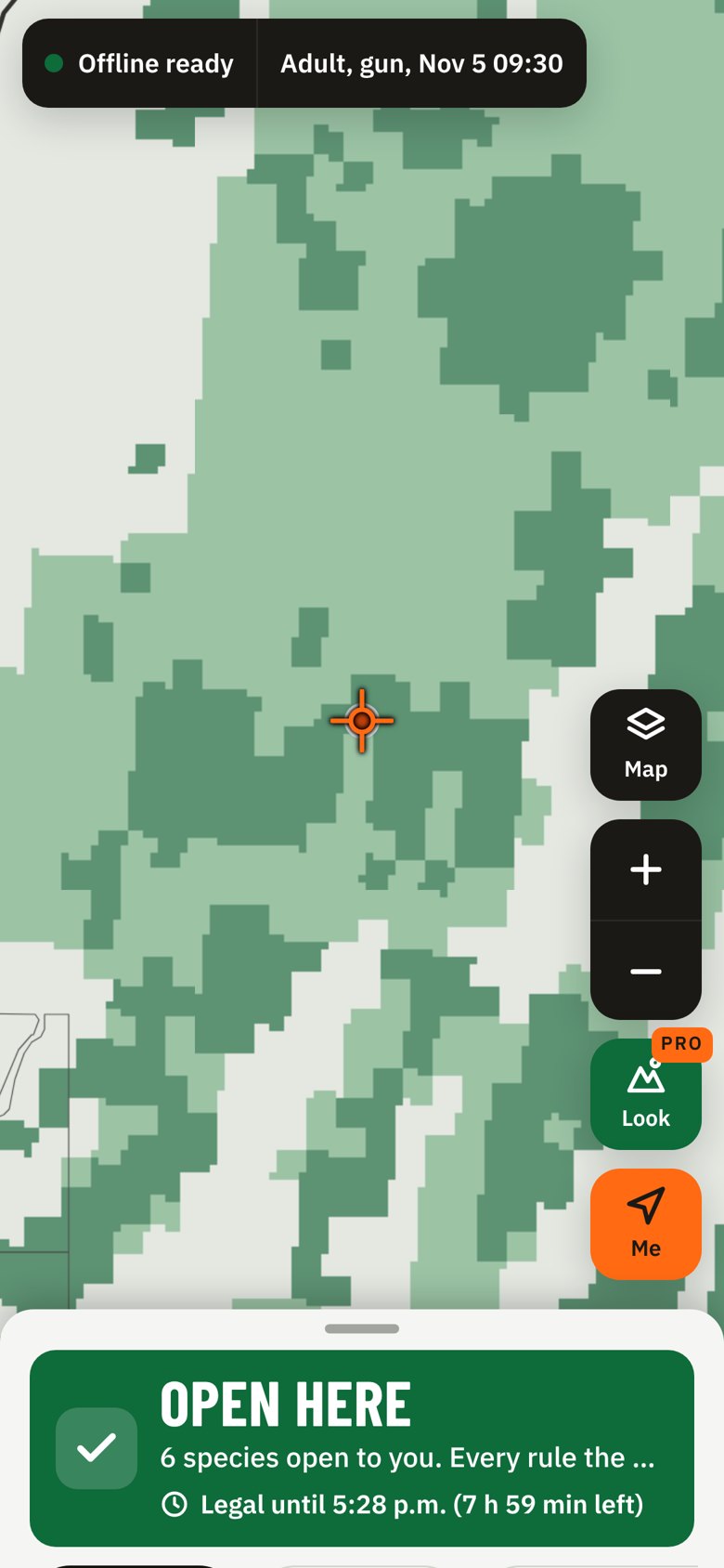
Where to look for moose near the Okanagan: green shading marks Prime and Good Crown land; the answer below is Open here.

Questions

Is Open here a guarantee?

No. It means every rule the app can check allows it. You're still responsible for knowing the regulations, for permission on private land, and for what you can see on the ground.

Where does the data come from?

The BC Hunting and Trapping Regulations Synopsis, ParcelMap BC, the Digital Road Atlas, BC parks and protected areas, and federal wildlife areas. It's rebuilt every two weeks, and the app tells you how old your copy is.

Does it cover Limited Entry Hunts?

Not yet. Huntable checks general open seasons. If you hold an LEH authorization, follow its own dates and area.

Which regions?

All nine BC hunting regions, from Vancouver Island to the Peace.

What if the rules change mid-season?

We watch the synopsis and its corrections every day. If the data gets more than 30 days old, the app stops answering Open until you update.

Is my location shared?

Huntable doesn't collect your location: every check runs on your phone. With signal, the topo and satellite map tiles load from the map provider for the area you're viewing.

Three hunters with shotguns standing in a field at sunrise.

Opening morning starts at the truck

Check the spot before you walk in, and again before you shoot. Get Huntable early on Android.

Get early access

Get Huntable early

We'll email you once when Huntable is ready on your phone, and invite early sign-ups to test it before launch.

Your phone

Only launch news, never shared or sold. Unsubscribe anytime from any email, or ask us to delete your address. See the Privacy Policy.